Showing posts with label Baden-Württemberg. Show all posts

Monday, January 16, 2017

Ettlingen - that pretty town near Karlsruhe where Napoleon once slept

Ettlingen is approximately 10 kilometers by bike from my home in Durlach, which means little less than 30 minutes at my rate of pedaling. The bike path is clearly laid out with good signage, is quite easy (with a few minor inclines and fun dips) and altogether a lovely ride which takes me through wooded area and strawberry fields along the way. 

Together with Durlach and Heidelberg, as well as many other communities on the right bank of the Rhine River across from French Alsace, Ettlingen suffered almost total destruction by fire at the hands of Louis XIV's troops during the Nine Years War (known in Germany as the War of the Palatinate Succession). The town's most well-known patroness, the Margravine Sybille-Augusta von Baden-Baden, widow of the famed Türkenlouis, Margrave von Baden-Baden, had the town rebuilt following the war and made the palace at Ettlingen her seat of power in her dowager years. Much of the city owes its present-day charm to the late Margravine.


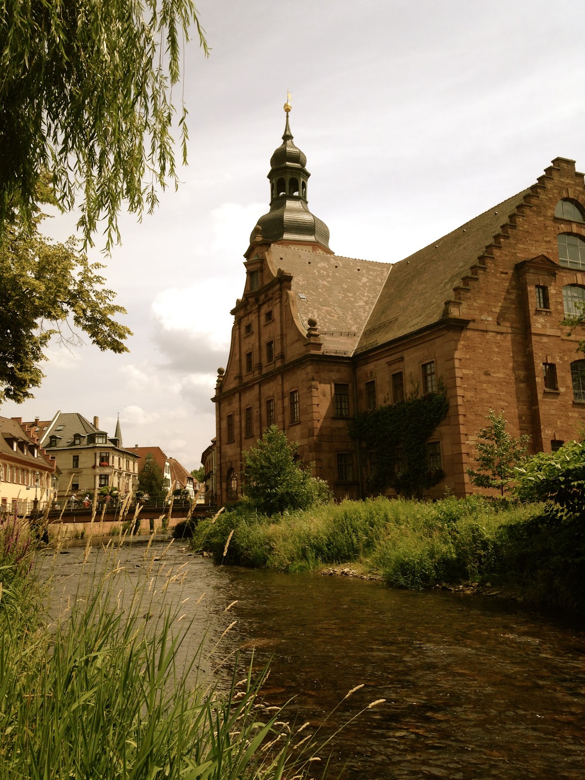
The Alb River flows directly next to the charming Old Town of Ettlingen


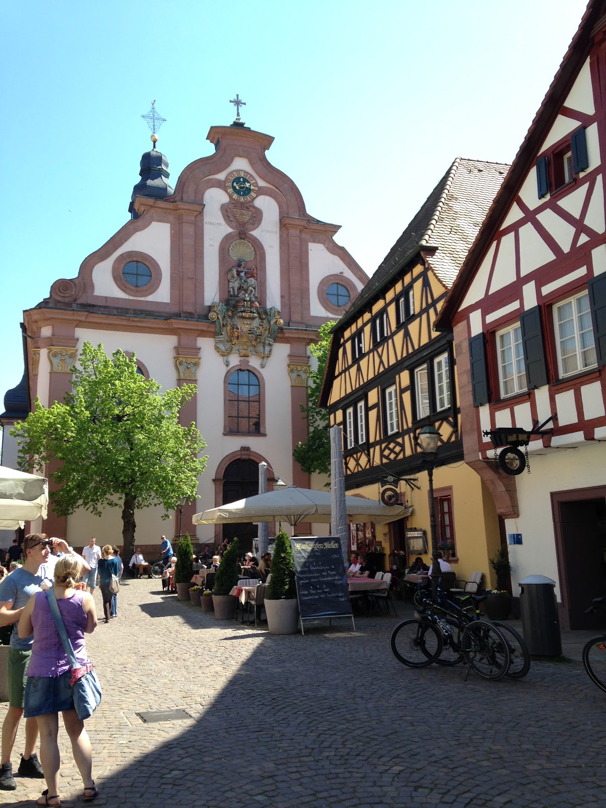
Marketplace with several restaurants and cafés next to the palace
Break from biking: on the wall along the Alb in Ettlingen


One of several bridges that span the Alb in Ettlingen. This is covered and also acts as a dam or weir.

The town of Ettlingen, which today boasts more than 30,000 inhabitants in its greater area, is definitely worth the visit. It doesn't require an entire day just to walk around and enjoy the charm and history, but if you are in the area, you shouldn't pass it up. You can visit Ettlingen and one of any other similar towns in the immediate area if history and early 18th-century architecture are your thing. You will find numerous outdoor cafés and restaurants and possibly also city events taking place in one of the two marketplaces or in the inner courtyard of the palace itself which hosts festivals and musicals.

The St. Martin's church, which is found not far from the Ettlingen Rathaus, was badly damaged during the Nine Years' War. The church predates many of the structures to be found in Ettlingen today. Under the church are what's left of a Roman bathhouse that dates back almost 2,000 years. 


St. Martin's Church is one of the oldest buildings
View of the Rathaus and tower gate.


Main walking street into and out of Ettlingen through the tower gate.


As someone who doesn't often make repeat visits to but so many places, Ettlingen is definitely one of the few destinations that I like to revisit time and time again, not only because it is so close to my home, but the charm and open atmosphere of the town attracts me to it. The clear water of the moving stream in the river is another draw for me and contributes to my feeling relaxed every time I go, even if for only an hour. 

Fountain found in the palace courtyard
Ettlingen Town Hall (Rathaus) on the Alb River
 

Since I also find half-timbered houses (Fachwerkhäuser) so fascinating, I enjoy biking around Ettlingen's  side streets in search of them and photographing what I find. The town, like so many in Germany, is certainly tourist-friendly, but it is also a living community which adds to its vibrancy. Just like in Colonial Williamsburg, Virginia, the dwellings are lived in which adds to the charm of these old houses. And as I confess I tend to do, peeking in windows through the corners of my eyes, I can register that these old wooden houses are still alive and are adding new chapters to their histories every day.


Another covered bridge and weir over the Alb near the Rathaus of Ettlingen. Note the birdhouses on the bridge.


A well cared for and restored half-timbered home in
Ettlingen
Looking down the Alb River as it passes the Old Town


One of the charming oddities in town, a private home
that may have once been squeezed into any available
space. Zoning may have been lax once upon a time.


Ice-cream shops are rather popular throughout Germany in the warmer months, and it can get pretty hot in Germany these days. Numerous ice-cream shops are also found here in Ettlingen mixed in with the cafés and restaurants along such streets as shown in the photo above. 

Well-marked bike paths and bike-friendly cities are also found throughout the Federal Republic and Ettlingen is no exception.


The tower standing over one of the main entrance to Ettlingen. This gate leads north to the next town, Durlach.


A beautiful example of "Fachwerk" in Ettlingen
Dating back to 1494, the St. George Fountain, protector
of the market place and watering hole, sits in front of the
Rathaus, or City Hall.


If you were to remove the plaster from this building, you would find the original half-timbered structure that it was. 


As mentioned above, the Margravine Sybille-Augusta of Baden-Baden took great interest in the rebuilding of this Ettlingen following devastation from the long War of the Palatinate Succession. By this time she was a widow and would end up living here in the palace (shown below) that was also rebuilt. Roughly a hundred years later, the Emperor Napoleon would briefly call  Ettlingen Palace his headquarters when passing through with French troops once again as they crossed the nearby Rhine during his campaign to attempt to subjugate Europe into his empire. However, on this trip the town was spared destruction.


Entrance to the palace chapel
A side view of the square-shaped palace. This side 
boasts two round towers on its corners. 


A larger view of Schloss Ettlingen The inner courtyard hosts musical festivals.


Pictured above, you can see the beautiful baroque city hall of Ettlingen that was constructed in 1738.  It is made of red sandstone, which is common in the region. The tower to its right straddles the gate that leads directly to Durlach to the north.


Another view of the Alb River


The Market Place just outside of the palace walls, which were behind me when I took the 
photograph (and still are!) You can see some of the many outdoor cafés in town.


Of course, if you are a beer afficianado, then perhaps the Vogelbräu in Ettlingen is a place you shouldn't pass up. Visit all three Vogelbräu sites by bike with the Tour de Vogel (Ettlingen, Karlsruhe, Durlach) in one day, and whichever brewery is your final visit will give you a free beer. Check the link here: Tour de Vogel (only in German). 


This house with its odd roof dormer window has always
intrigued me. There are two floors in that peaked roof.
A later shot of the tower without the scaffolding.


A final shot of the Alb River taken from the other side of the river, with St. Martin's church tower in the background. 


How to get to Ettlingen: 

From Karlsruhe HBF (main train station) - The S1 or S11 tram leaves from out front of the train station roughly every ten minutes in the direction of Ettlingen. It takes about 14 minutes. No passenger trains run there.

By bicycle - Follow signs from the Karlsruhe train station or from Durlach or even from Baden-Baden, located to the south of Ettlingen. Asking the Tourist Info Center, or possibly just about any cyclist you run into, might also give you a good head start. The ride shouldn't be more than 30-40 minutes depending on your speed. maybe even faster? You might be able to lease a DB (DeutscheBahn) bicycle from out front the station as well.

(By the way, The Durlach to Baden-Baden bike route (roughly 40 km.) takes you directly through Ettlingen, and it is a good ride on relatively flat terrain passing through nice villages, ending up in Baden-Baden, which is another jewel of a town to visit! It is roughly the same distance from Karlsruhe main train station to Baden-Baden as well.)

By car -  get a map or use your navigator ;-) It isn't far at all. If it takes a cyclist less than 40 minutes to get there, you shouldn't have long in the car, save traffic problems.

Walking - I certainly do not see why not. You could easily get there on foot and after a nice morning of walking there, you can enjoy a beer at Vogelbräu or lunch at one of the nice outdoor cafés.

Saturday, February 6, 2016

The Ruins of Hohentwiel


I'm really late in posting this trip, but it really doesn't matter because the place was in ruins long before I ever got there, so nothing has really changed since my visit with the Duchess. 

In the photo above, you can see a rendering of the Burg, or fortress, of Hohentwiel when it was at its best in the 17th and 18th centuries. The stone ruins that you will see in the photographs below are all that is left of the once mighty fortress-castle that has stood here in different forms and sizes since the first structure was built way back in the year 914. 

Interestingly, the hill on which Hohentwiel sits is actually an extinct volcano, and the countryside around it gives evidence of this in its rock formations and terrain.


Our trip via train from Stuttgart to Hohentwiel, near the southern German city of Singen, very near the Swiss border, took us through foothills and glens on the eastern side of the Black Forest. The journey was about 2 hours and the scenery along the way is truly lovely, especially in spring when we made our particular trip. Blossoming fruit trees mixed with three different shades of lilac are found in abundance throughout the country; nature's freshly made colors spattered throughout our vista from the rail car could have taken up a lot of space on my camera had I let them.


We passed numerous smaller stations some of which were better cared for than others. A good number of the railway stations of smaller municipalities date back almost to the origins of rail service in the former Kingdom of Württemberg. Often they are inhabited on their upper floors even if the ticket counters are now closed on the ground floor. Some, such as the one pictured above, are in full operation with perhaps a café still an integral part of the complex. 


Looking westward from our windows, some of the lower ridges of the Black Forest range were in sight, as you can see in the photo above and in the one below. A bit further westward and out of view for us, the Black Forest rises even higher offering excellent views of the Alsace regions of France along with some of her smaller mountain ranges found there. 


When we got to Singen's main station, we had to transfer to a regional train which took us only one or two stops to the platform from which we began our ascent on foot up to the castle ruins atop Hohentwiel. It's a great walk! Along the way, the Duch and I had a good laugh, mostly due to her rolling her eyes at the fact that I seemed to have to stop and photograph almost every piece of creation along the way. Below, you can see one of a number of huge mushrooms I found; the sheep in the background could clearly care less. Although we were attempting to make this quasi-hiking excursion as much about being outdoors and getting good exercise, my constant stopping to take a photo just might have thrown a bit of a wrench into any idea of making the climb a vigorous one. Thanks, Duchess, for your patience and good humor about it.


At one point, you come to a collection of houses and dependencies, many of which offer information about the ruins further ahead. The model rendering of the castle at the beginning of the post was found in an information center located here. To add to my photo-excitement and to the greater dismay of the Duchess, an old cemetery (seen below) was also found here along the path just past the info. center, and, well, of course I couldn't pass that up. I think it was here that the Duch began wondering if we would ever make to the top before winter. 


I won't spend a lot of time writing about the cemetery here because the Duchess is eager to get going, so onward and upward, literally, to our Ziel: the castle-fortress of Hohentwiel.


The Duchess awaits, "C'mon Jeeves!"
Entrance to info/visitor's center


Well, as you can see below, we weren't the only living beings on this trek. There were other two-leggers as well as a herd of four-leggers along the path; only, the four-leggers weren't exactly clogging the route to our destination, fortunately. We traversed open as well as leaf-canopied ways up the hill and the distant views expanded even further until at one point, while at the top, we were able to enjoy a marvelous view of the Bodensee, or Lake of Constance, shared by three nations: Germany, Switzerland, and even Austria.


When we finally came round the bend, we were at the entrance to the fortress complex. Of course we could see the place from just about every clear vantage point below as we made our way up, but now we were standing directly at the base of the daunting walls which loomed above us. One thing that did indeed surprise me, or better yet, impress me, was that the buildings had so many floors in them. When I look at the amount of stones required to build these structures, along with the mortar to keep them all from tumbling down, I have to remind myself that taller and more immense edifices had been built hundreds if not thousands of years prior, so it isn't like such feats of construction had never been accomplished prior to this. I guess it's because we there in the flesh and not looking at a photo in a book and thus were able to appreciate the scale of the buildings three dimensionally. Imagine standing directly next to the great pyramids of Giza or the magnificent stone structures that still remain from the Aztecs. All of this makes an impact that photos cannot fully express.


There are several levels of the Burg Hohentwiel that one must make their way through in order to get to the highest point. Scroll back up and have a look at the model in the first photo. There, you can easily see the ramp climbing the center-left of the castle from the lowest gate, which can be seen in the two photos directly below. The photo to the right is the principal entry and leads into what appears to be a tunnel, as seen in the photo on the left.


I could stand and look at these walls all day, wondering what each of the window-like openings actually were. Were they doorways? Windows? Fireplaces? Hidden alcoves? And what if they weren't doors but large windows and the smaller  openings were fireplaces? Then why were the fireplaces higher than the foundation of the doorways? Hundreds of childlike questions, many of which I would prefer to remain unanswered merely because I like my theories better (LOL). 


One of the questions I always have when visiting such places is what all the other buildings were used for. Well, a place like Burg Hohentwiel needed to support itself as well as possible within its own walls in the event of a siege. So one can image there would have been need of everything from an apothecary and blacksmith to food and water storage, stores, as well as anything associated with military preparedness. There are many buildings to be found here and also quite substantial in size. It was like a mini-city of sorts with a well-guarded wall around it. Just imagine a military base today and take it back a couple of hundred years.


The View

I regret that I have no photograph of the Bodensee from atop Burg Hohentwiel. Truth be told, the haze over the lake to the east-southeast together with the glare of the late afternoon sun behind me to the west created some sort of gauze-like image that photo-shopping could do little to minimize. Believe me when I write here, however, that although the camera images were all a mess, the view is wonderful. The lake is immense, so to see so much of it from high above and at the distance that it actually is, it causes one to appreciate its size as well as all the landscape in which it sits. Keep in mind that on a clearer day, we would have been able to see the Alps from there as well. Definitely, we were able to look across into the Canton of Thurgau, Switzerland although the Alps themselves were not on display for us at that time.


In the photo above (right) you can see the second gate that leads to the highest part of the castle complex. It is the last portal entry well within the greater castle complex. If you look again at the diagram at the very top of this page, you can't see it, but the other tow gate houses that precede it can be seen on the sloping ascent in the model. If any invader had gotten into the first section of the fortress at its base, they would have still had a long way to go to get the rest of way to fully conquer it.


I wouldn't be able to tell you exactly what these cavernous cellars were used for. Yeah, I'm sure somebody knows down at the information center below, but I didn't ask since I didn't know we would be seeing them way up above on the hill, but that just makes it all the interesting for you when you go there. Besides, if I gave away all the secrets to be found there, you wouldn't have many surprises to discover on your own. Oh, just one thing: when down in the cellars, you might want to watch out for ghosts - just sayin'.


You know, when you're down in the man-made caverns and think of all that was dug out down there along with all the masonry above and around you as well as the immense number of stones possibly hewn from the volcanic rock on which this immense Burg stands, it makes you think - think about what we are all capable of accomplishing when we get off our seats and do it!


A Burg Hohentwiel spring in Baden-Württemberg


Not visible in the photograph due to haze, the Lake of Constance spans out in the horizon
beyond the large, faint forest that can just be made out in the distant background above.
On a clearer day, the view would be most obvious from atop Burg Hohentwiel.


Note all the stones that make up these walls. The cellar, too, is lined
with the same type of rock (I'm guessing volcanic.) and is quite
deep, hence my staying back a bit to take this photo.


This shot (above), taken from the walls of Burg Hohentwiel looking north, shows another ancient volcano in the near distance. I don't know if there are any ruins or former fortifications of any kind up there. Still, I would think it would have been used for something once upon a time.

Well, I gather that by now many of you might be wondering why in the world this place is in ruins today. After all, it was one of the most solid and strongest of fortresses in this part of Europe once upon a time. From what I recall, the fortress was never overtaken directly from war. At one point in its long history, it was even a ducal residence of the dukes of Württemberg. Even though this area is technically in the Baden part of the present federal state of Baden-Württemberg, it was nonetheless an enclave of sorts which was owned by the former rulers of Württemberg. It served its purpose until the very early 1800s, when Napoleon ordered that the fortress be dismantled. Hence, the ruins we see today came not from neglect or as the result of warfare, but simply the orders of Napoleon. I should like to add here, that only a few years later the dukes of Württemberg, who chose to side with Napoleon in his restructuring of the former Holy Roman Empire, which he also abolished during his reign, were elevated to the status kings of Württemberg and the Badener margraves were elevated to the title of grand dukes of Baden. 

The Kingdom of Württemberg ceased to exist in November of 1918 in the closing days of World War I (see Bebenhausen-where-it-all-ended.html), and the Grand Duchy of Baden became a Freistaat or Free State (Republic) at about the same time within the new Germany. Descendants of both royal families still live in the lands of their ancestors and participate in various ways to local cultural and educational concerns. Of course they have long relinquished the titles of king and grand duke, but have retained the ancient titles their forebears once used and are now known within the modern republic once again as dukes of Württemberg and markgraves of Baden, of course without political power, but as citizens equal to the rest of us. 


Visiting here and reading about and seeing the history of Burg Hohentwiel is something that is also educational for children. The hike of the well-paved hill to get up there provides a good day-trip outing and the views are truly spectacular if you are there on a clear day. 

___________________________


Getting there by train from Stuttgart main station, there are two options: 

a) the regional (RE) which departs roughly every two hours and takes 2:24 minutes non-stop, and

b) the inter-city (IC) which also departs every two hours, alternating with the RE on the between hour, also non-stop.

Check www.bahn.de for prices and times.

In all cases you will need to change trains at Singen (your final destination from Stuttgart or any other place of departure) for the short jaunt around the bend to the foot of the Burg where your hike upward will begin. Of course it is certainly possible to begin your day-jaunt from the Singen train station itself. Just add some time onto your trip and take a map. When we came down the mountain after a visit, we came by foot all the way through the city of Singen to the train station to return to Stuttgart.

Singen is not at all far from Zürich via train or car, and is also close to other beautiful sites such as Mainau, Friedrichshafen and Konstanz.

Have fun!

And don't forget to join this blog (see column to the right) for updates on new postings to come!


Detour into the Principality of Liechtenstein

When I first started this blog some years ago, I began by committing to my own photos, stories and historical explanations of places locate...